Villavicencio
Department

Flag of the city
The Flag of Villavicencio It was adopted on October 23 of the year of 1970. This same day also adopted the other badge of the city: its shield. The flag of Villavicencio symbolizes the great riches of this city, both in soil and in rivers.
Additionally, they also wanted to represent the great struggle of the people to achieve the independence of the Spanish Crown.

Slogan of the city
Villavicencio, Colombia, is often referred to as “The Door to the Llanos” or “Gateway to the Llanos” (“La Puerta al Llano” in Spanish) due to its strategic location as the main urban center before entering the vast Eastern Plains (Llanos Orientales) of Colombia.
History
In 1536, Nikolaus Federmann, a German Conquistador, ventured into the altiplano of Bogotá by navigating from the plains of Venezuela, which is a part of the vast Orinoco basin. Although he reached the altiplano, the expansive plains region went largely untouched and uncolonized for another three centuries. The main settlements in Colombia grew in the mountainous regions along the Magdalena and Cauca valleys. The majority of its trade with the external world was directed towards the Caribbean Sea. The formidable mountain barriers, coupled with the extreme heat and hostile climate, led to the Llanos being overlooked and unsettled for a significant time.
The Llanos’ inhabitants, known as Llaneros, were skilled horsemen. Initially, they served the Spanish royalists, but later they sided with Venezuelan and Colombian rebels during the War of Independence. It’s notable that during the independence movement, they joined forces with Simón Bolívar. Together, they launched a surprise attack on the royalist army on Boyaca’s plains on August 6, 1819. This victory paved the way for them to take control of Santa Fe de Bogotá soon after.
By the 1840s, settlers from Caqueza, a town near Bogotá, began to establish the humble settlement of Gramalote. This later was recognized as the parish of Villavicencio in 1855, named in honor of Antonio Villavicencio, an independence war hero. The advent of vaccines, improved road connectivity, and the lure of vast, free lands accelerated Villavicencio’s colonization. With better roads, local farmers could easily transport their goods and livestock to Bogotá’s markets.
A significant event in 1948 saw many farmers being evicted from their lands, partly due to the aftershocks of the assassination of the renowned Liberal leader, Jorge Eliecer Gaitan. The Llaneros fiercely opposed this, pushing the army out of populated regions. Although guerrillas couldn’t capture Villavicencio, they managed to bring the battle right to the Apiay military base. The conflict became so severe that it led to a military coup in June 1953, elevating Gustavo Rojas Pinilla to power. He quickly brokered a ceasefire and granted amnesty to the rebels.
From 1948 onward, Villavicencio experienced substantial growth. What started as a modest settlement with a handful of inhabitants in the 1850s blossomed into a bustling city with over half a million residents by 2018. Modern infrastructure, including a network of bridges and tunnels, has reduced travel time to Bogotá. This enhanced connectivity greatly aids the swift transportation of oil, cattle, and agricultural commodities.
Geography of the city
Villavicencio is situated in the Orinoquia region, marking the commencement of the Oriental Plains. Predominantly, the city sprawls across flat terrains that gradually slope away from the Andes Mountains. To its north and east, the Guatiquia River forms natural boundaries. The city is neighbored by Caqueza and Chipaque to the northwest. Serving as a gateway to the Llanos, roads from Villavicencio stretch southward, connecting it to places like Acacias and San Martin. San Martin holds historical significance as one of the Llanos’ earliest towns, with roots tracing back to an initial Jesuit settlement. To the east of Villavicencio, or often referred to as “Villavo”, roads lead to locations like Apiay and Puerto Lopez, culminating at the river port of Orocue on the Meta River—a significant tributary of the mighty Orinoco.
Villavicencio is nestled in the Orinoquia region, serving as the entry point to the Oriental Plains of Colombia. Geographically, Villavicencio lies approximately at a latitude of 4.15° North and a longitude of 73.63° West. The city is positioned at an altitude of around 467 meters (1,532 feet) above sea level. This elevation contributes to its tropical climate. The Guatiquia River skirts the city to the north and east. Northwest of Villavicencio are the towns of Caqueza and Chipaque. As a principal gateway to the Llanos, roads from Villavicencio stretch south, linking it to Acacias and the historically significant San Martin, an initial Jesuit settlement. Eastwards from “Villavo”, pathways lead to places like Apiay, Puerto Lopez, and culminate at the river port of Orocue on the Meta River, which is a major tributary of the expansive Orinoco River.
Population
570,000 (2023)
562,000 (2022)
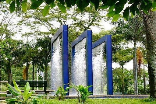
One photo representative of the city
Los Fundadores Park, which measures six hectares, is the largest in Villavicencio and can be seen when arriving by road from Bogotá. It has a small square in the center of which stands the monument to the Founders, by the artist Rodrigo Arenas Betancourt; It has a food court, a children’s square, a theater and a lovers’ square. In the park you can walk along pedestrian paths and see a water fountain.
Etymology
“Villavicencio” was derived from the words “Villa” and “Vicencio”. “Villa” is the Latin word for a country house, a country estate, a manor, farm or village while “Vicencio” came from the Spanish personal name “Vincencio” whose Latin word is “Vincentius”. The word “Vincentius” was derived from the word “vincens” whose genitive is “vincentis” and is the present participle of “vincere” which means “to conquer”. “Vincentius” means “conquering” and was used as a personal name describing a person’s victory or describing his characteristics.
The surname “Villavicencio” originated from Spain from the place-name “Villavicencio de los Caballeros”, a place in the Valladolid province of north-central Spain. The surname was derived from the name of the place where its original bearer resided.
What the city is known or famous for
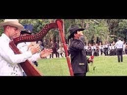
Villavo,” as the city is affectionately called, is characterized by llanero folklore and traditions like coleo (an event where small groups of llaneros, Colombian cowboys or herders, pursue cattle on horseback) and joropo music, which uses instruments like harps and maracas to get everyone on their feet and dancing