PUERTO ASÍS
Department

Flag of the city
The flag of Puerto Asís has three colors which are red, white, and red. These colors are representation of the city’s culture, beliefs, values, and heritage.


Slogan of the city
The city does not have a specific slogan. However, the slogan of its department, Putumayo, is “Enchanting paradise”. The slogan emphasizes the beauty of the municipalities of the department
History

The history of the southwestern area of the Putumayo Department is intricately linked to the indigenous communities that inhabited the region. Originally, the land was divided among various indigenous groups, with the Cofán Indians in the southwestern area, the Kamentxá Indians in the northwestern part, Tukano-speaking tribes like the Siona in the central and southern areas, and Witoto-speaking tribes in the east. In 1492, Inca Huayna Cápac expanded the Inca Empire into part of the Kamentxá territory. Crossing through Cofán territory, he established a Quechua population in the Sibundoy Valley, now known as the Ingas. However, after the Inca’s defeat in 1533, the Spanish arrived in 1542, invading the region and subsequently administering it through Catholic missions from 1547. During the Spanish Colonial Period, the territory of Putumayo was linked to Popayan, and in the early years of the Republic, it belonged to the “Azuay Department,” which also included territories in Ecuador and Peru. Over time, the region underwent significant changes in its administrative status: In 1492, Inca Huayna Cápac expanded the Inca Empire into part of the Kamentxá territory and established a Quechua population in the Sibundoy Valley, known today as the Ingas. However, the Spanish invaded the region in 1542 after the Inca’s defeat in 1533, administering it through Catholic missions from 1547.
During the Spanish Colonial Period, the territory of Putumayo was linked to Popayan. In the early years of the Republic, it belonged to the “Azuay Department,” which included territories in Ecuador and Peru. Over time, the region underwent changes in its administrative status, transitioning through various designations such as the Popayán Province (1831), Estado Federal del Cauca (1857), and the Cauca Department (1886). The Intendencia del Putumayo was established in 1905, followed by the creation of the Intendencia del Caquetá in 1909. The region became the Comisaría Especial del Putumayo in 1912. In the mid-20th century, there were brief incorporations into the Department of Nariño in 1953 and a reversion to the status of Comisaría Especial del Putumayo in 1957. In 1968, the region was designated as the Intendencia Especial del Putumayo. Finally, in 1991, the region gained its present status as the Putumayo Department, reflecting the historical and political changes that occurred in the transition from the colonial period to the modern administrative divisions of Colombia.
Geography of the city
Puerto Asís has a tropical rainforest climate (Af) with heavy to very heavy rainfall year-round. The city has a total area of 2,819 square kilometers (1,088 square miles) within its municipality, while the urban area covers 5.63 square kilometers (2.17 square miles). The elevation of the city is approximately 250 meters (820 feet) above sea level. As of the 2020 estimate, the population of the municipality and the city is 67,211, with a population density of 24 individuals per square kilometer (62 per square mile) across the entire municipality. In the urban area specifically, there are 40,549 residents, and the urban population density is 7,200 individuals per square kilometer (19,000 per square mile). These figures provide insights into the spatial distribution and population concentration within the city and its surrounding municipality.

Population
Municipality and city 67,211 (2020)
Urban 40,549 (2020)
One photo representative of the city

Etymology
The city does not have a clear etymology. However, the name is suspected to be rooted in its cultural heritage and belief. It is also possible to be associated with its founders
What the city is known or famous for
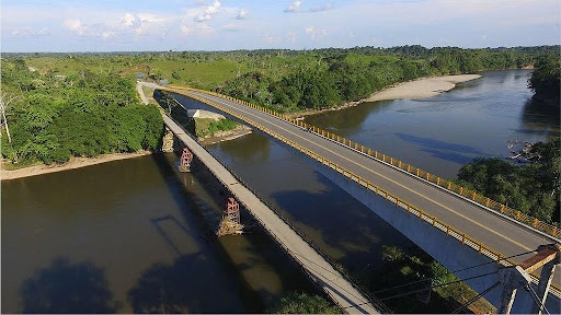
Puerto Asís, located in the Putumayo Department of Colombia, is renowned for its geographical setting in the heart of the Amazon rainforest. The town serves as an economic center, notably in agriculture with the cultivation of crops like oil palm and cacao. Its strategic position along the Putumayo River facilitates trade, making Puerto Asís a hub for commerce between Colombia and neighboring countries, particularly Ecuador. The town boasts cultural diversity, housing indigenous communities, Afro-Colombians, and other ethnic groups, each contributing to a rich tapestry of customs and traditions. Puerto Asís is often considered a gateway to the Amazon, attracting those interested in exploring the rainforest’s unique ecosystems and wildlife. Additionally, the town’s history is marked by the presence of indigenous communities and the influence of the Inca Empire, followed by Spanish colonization, shaping its cultural and historical narrative.