FUNZA
Department
Cundinamarca Department, Colombia

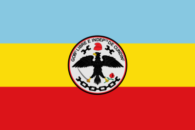
Flag of the city
The colors of Funza’s flag being red and white are a distinctive representation of the municipality. These colors hold local significance or symbolize certain values or aspects related to Funza’s identity.

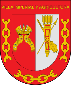
Seal of the city

Slogan of the city
The slogan “Imperial and Agricultural Village” reflects Funza’s pride in its agricultural heritage and perhaps emphasizes a sense of grandeur or importance associated with the locality. It suggests a connection to agricultural traditions and may highlight the significance of Funza as a key hub in this sector.
History

Funza, located in the Western Savanna Province of the department of Cundinamarca, Colombia, holds a rich historical legacy. Nestled on the Bogotá savanna, the town is positioned at an elevation of 2,548 meters, showcasing the unique La Florida wetland—a remnant of the Pleistocene Lake Humboldt and part of the broader wetlands of Bogotá. In the pre-Columbian era, Funza was a significant village within the Muisca Confederation, playing a pivotal role in the southern region ruled by the zipa based in Bacatá, the present-day municipality of Funza. The area was densely populated and served as a key settlement for the indigenous Muisca people. The modern history of Funza is intertwined with the Spanish conquest led by Gonzalo Jiménez de Quesada. On April 20, 1537, during the quest for El Dorado, Quesada founded the town, marking the establishment of modern Funza. This event shaped the cultural and social landscape of the region, blending indigenous heritage with Spanish influences.
Tragically, on January 21, 1972, Funza became the site of a significant aviation incident. A Líneas Aéreas La Urraca flight crashed in the town after an onboard explosion, leaving a lasting impact on the local community. Funza, today, stands as an integral part of the Metropolitan Area of Bogotá, bordered by Madrid and Tenjo to the north, Mosquera to the south, Madrid to the west, and Cota and the locality of Engativá in the capital city of Bogotá to the east. The Bogotá River forms the eastern boundary, symbolizing the historical and geographical significance of Funza in the Colombian landscape.
Geography of the city
Funza is characterized by a geographical profile that intricately weaves together elevation, urban development, and a rich historical backdrop. Nestled at coordinates 4°43′3″N latitude and 74°12′34″W longitude, Funza’s strategic location on the Altiplano Cundiboyacense contributes to its unique climate and topography. Encompassing an area of 67.75 km², the municipality is a mosaic of landscapes, incorporating an urban expanse of 7.78 km². The town is perched at a noteworthy elevation of 2,548 meters (8,360 feet) above sea level, providing panoramic views of the surrounding region. This elevated terrain not only shapes the town’s physical characteristics but also influences its climate and vegetation. According to the 2018 census, Funza was home to a population of 93,154 residents. This populace is distributed across both the municipality and the urban area. The density of Funza’s municipality is recorded at 1,400 people per square kilometer (3,600/sq mi), reflecting a vibrant community within a relatively compact space. In the urban core, with an impressive density of 12,000 people per square kilometer (30,000/sq mi), Funza thrives as a bustling center of activity and residence. This geographical configuration, coupled with the town’s historical significance, positions Funza as a dynamic and culturally rich municipality within the Metropolitan Area of Bogotá. From its indigenous roots to the Spanish conquest and into the present day, Funza’s geography serves as a backdrop to its evolving narrative, making it a distinctive and vibrant part of Colombia’s landscape.

Population
Municipality and town 93,154 (2018 census)
Urban 90,671 (2018 census)
One photo representative of the city

Etymology
The name Funza carries a profound historical resonance, rooted in the Chibcha language, where it emerges as a testament to the town’s significance. Derived from Chibcha, the name “Funza” holds a rich etymological meaning, translating to “Powerful Lord.” This linguistic heritage encapsulates the cultural and historical depth of the town, reflecting its role as a powerful and influential entity. As Funza continues to evolve, its name remains a symbolic link to its past, echoing the strength and prominence embedded in its Chibcha origins.
What the city is known or famous for

Funza is renowned for its historical significance, serving as the site of the former main settlement Bacatá of the Muisca Confederation. In pre-Columbian times, it was an important village within this confederation. Additionally, Funza holds cultural and environmental importance due to the presence of La Florida wetland, part of the wetlands of Bogotá. This wetland is a remnant of the Pleistocene Lake Humboldt. The town’s association with Gonzalo Jiménez de Quesada’s exploration and its role in the Spanish conquest adds to its historical prominence. Overall, Funza stands as a place deeply intertwined with Colombia’s indigenous heritage and colonial past. The economy of Funza is based on agricultural and industrial activities. Main agricultural products are potatoes and maize. Other industries involve plastics and metalcraft production.
