COPACABANA
Department
Antioquia, Colombia

Flag of the city
The city flag has four colours which are green, red, blue, and yellow. The green, red, and blue colors are arranged horizontally. The yellow colour is an arrow extending to the center from the left hand side

Seal of the city

Slogan of the city
The city flag has four colours which are green, red, blue, and yellow. The green, red, and blue colors are arranged horizontally. The yellow colour is an arrow extending to the center from the left hand side
History

Copacabana, a Colombian gem, unfolds its captivating history dating back to its foundation in 1615. Steeped in colonial origins, the town has evolved into a vibrant municipality, each cobblestone echoing the footsteps of its founders. Founded during an era marked by Spanish colonial expansion, Copacabana emerged as a settlement reflecting the ambitions and dreams of its early inhabitants. The town’s inception aligns with the broader historical context of Spanish exploration and establishment in the Americas. Copacabana’s founders, imbued with a pioneering spirit, sought to carve out a community amidst the Colombian landscape. Their vision laid the groundwork for what would become a thriving municipality, blending indigenous influences with Spanish colonial traditions. The colonial legacy is palpable in Copacabana’s architectural treasures. Preserved colonial-era structures, such as churches and homes, stand as testaments to the town’s enduring commitment to conserving its historical identity. Strategically situated in proximity to Medellín, Copacabana’s location played a pivotal role in its early development. The town’s founders likely recognized the strategic advantages of its position, contributing to its growth and significance in the region.
Geography of the city
Situated in the Colombian highlands, Copacabana unfolds its geographic tale with coordinates placing it at 6°20′N latitude and 75°30′W longitude. Copacabana is positioned at a latitude of 6°20′N and a longitude of 75°30′W. Nestled in the Andean region, its elevation reaches a majestic 1,454 meters (4,770 feet) above sea level. This elevated vantage point offers sweeping views of the surrounding highlands. The municipality of Copacabana encompasses a total area of 67.76 square kilometers (26.16 square miles). This expansive territory includes both urban and rural landscapes, each contributing to the municipality’s rich tapestry. Within Copacabana’s boundaries, the urban area covers 7.62 square kilometers (2.94 square miles). This urban expanse is characterized by a vibrant community, bustling streets, and the architectural nuances that reflect the town’s historical journey. As of the 2018 census, Copacabana is home to a population of 77,884 residents. The municipality’s population density is calculated at approximately 1,100 individuals per square kilometer (3,000 per square mile). The urban core, with 62,343 residents, contributes to an urban density of 8,200 individuals per square kilometer (21,000 per square mile).
The topography of Copacabana is shaped by the undulating terrain of the Colombian highlands. Mountains, valleys, and ridges create a picturesque backdrop for the town, offering both challenges and opportunities for development. With an elevation surpassing 1,400 meters, Copacabana enjoys a climate influenced by its highland location. The air is crisp, and the landscape is adorned with greenery, contributing to a serene and refreshing ambiance.

Population
77,884 (2018 census)
79, 132 (2023 projection)
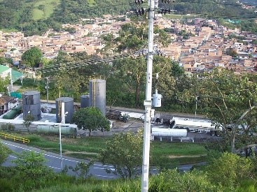
One photo representative of the city

Etymology
The name “Copacabana” carries a charming etymology that echoes cultural and geographical resonances. Derived from Spanish, it is a composite term, combining “Copa” and “Cabana.” The term “Copa” is often associated with a rounded object or structure, resembling a cup or bowl. In the context of Copacabana, it might evoke images of the natural contours of the land or perhaps reference a particular geographical feature with a rounded or bowl-like appearance. This term is commonly used to describe a simple, cozy dwelling or shelter, often associated with rural or scenic locations. In the context of Copacabana, it could allude to the town’s setting amid the picturesque Colombian highlands. The amalgamation of “Copa” and “Cabana” in the name Copacabana paints a vivid picture of a place where natural beauty, perhaps akin to a cup-shaped landscape, meets the warmth and simplicity associated with a shelter or dwelling. This etymology encapsulates the essence of Copacabana, hinting at a harmonious coexistence between the land’s physical attributes and the human connection to its surroundings.
What the city is known or famous for

Copacabana, a municipality in Colombia, is recognized for its cultural, historical, and scenic attributes. Copacabana, with its foundation dating back to 1615, carries a rich cultural heritage. The town’s history, shaped by centuries of human presence, adds to its significance within the region. Situated in the Colombian highlands, Copacabana is likely renowned for its picturesque landscapes. The town’s elevation and natural surroundings contribute to its visual appeal, attracting residents and visitors alike. The town’s identity may be deeply tied to its community spirit and adherence to traditions. Festivals, local customs, and a sense of community cohesion might be notable aspects contributing to Copacabana’s reputation.
