Barranquilla
Department
Atlántico, Colombia.

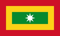
Flag of the city
In 1811, the patriots who played a vital role in achieving independence for the Cartagenas region embraced the flag that is still in use today. This flag is composed of three rectangular sections: an outer red stripe, a middle yellow stripe, and a central green stripe. The symbolism behind these colors is profound: red represents the sacrifice of the patriots, yellow signifies the sun of freedom and hope, and green stands for a proud homeland. Positioned at the center of the flag is an eight-pointed silver star, symbolizing the eight provinces of the confederacy. Simon Bolívar himself carried this flag during the Lower Magdalena campaign in 1812. Subsequently, in 1814, the Congress of Tunja officially adopted it as the emblem of the United Provinces of New Granada. Finally, in 1910, the flag was formally approved for use in Barranquilla by the city council.

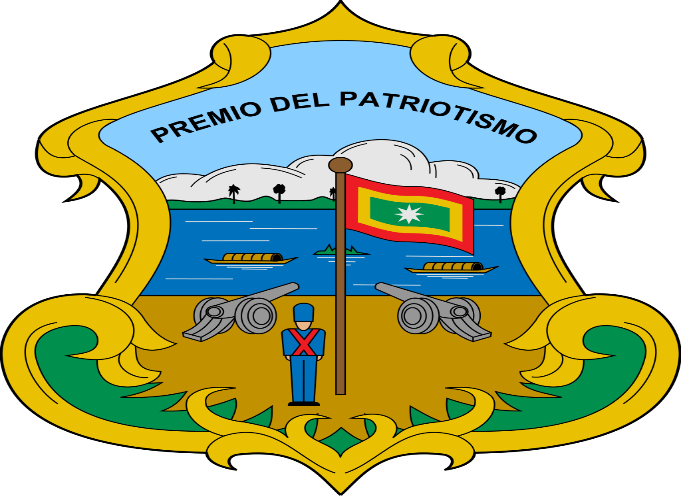
Seal of the city

Slogan of the city
Colombia, is “Barranquilla: Puerta de Oro de Colombia,” which translates to “Barranquilla: Golden Gate of Colombia.” This title underscores Barranquilla’s historical significance as a major port and its economic and cultural importance to Colombia.
History

Barranquilla, unlike other Colombian cities like Cartagena or Bogotá D.C., wasn’t founded during the Spanish colonial era or on a pre-Columbian site. The earliest reference to Barranquilla’s present territory is from 1533, penned by Gonzalo Fernández de Oviedo y Valdés. He detailed Pedro de Heredia’s route, who later founded Cartagena. He noted this area as a landing point for the native Indians of Santa Marta. These Indians traded commodities such as dried shrimp, salt, and others using the Magdalena River. The Kamash Indians are known to have settled the area, with the actual settlement forming around 1629. Hence, the city commemorates the day it was designated a town on April 7, 1813, rather than its foundation date.
Barranquilla holds distinction as the birthplace of aviation and the airport in South America. The first South American airline, SCADTA, which later became Avianca, originated here.
The site initially inhabited by the Kamash indios became Barranquilla’s first consistent human settlement. In the 16th century, Captain Domingo de Santa Cruz established an encomienda given by the Spanish crown for his military feats. This encomienda vanished in 1559. It was then under Ana Ximénez, widow of Santa Cruz, who fell victim to a hostile act by the second encomendero of Galapa, Don Pedro de Barros I.
A plaque in Barranquilla marks the area where the city began its development. Between 1627 and 1637, Hacienda San Nicolás de Tolentino emerged, founded by Nicolás de Barros. The property started at 24.78 km2 but expanded to 41.3 km2. Here, workers were allowed to build homes and support their families. By 1681, the ranch, known as Barrancas de San Nicolas, was considered a village. Barranquilla’s origins, as popularized by historian Domingo Malabet in the late 19th century, were challenged and debated.
During the Colombian War of Independence, Barranquilla stood out as a supporter of pro-independence groups. In 1813, it was declared the capital of the Barlovento department for its role in defending Cartagena de Indias against royalist forces from Santa Marta. By 1821, Barranquilla had its first mayor, Agustín Del Valle. In 1823, the naval Battle of Lake Maracaibo concluded, resulting in the Spanish royalists’ final departure from Gran Colombia.
Geography of the city
The city of Barranquilla is situated in the northeastern part of the Atlántico Department, nestled on the western side of the Magdalena River. It’s approximately 7.5 km from where the river merges into the Caribbean, though this distance was once about 25 km before urban expansion. Spanning an area of 154 km², Barranquilla makes up roughly 4.5% of the Atlántico Department’s territory. Geospatially, its coordinates are approximately 10° 59′ 16″ N latitude and 74° 47′ 20″ W longitude, centered at the Plaza de la Paz, the city’s focal point. The city terrain is a gentle incline, ranging in elevation from about 4 m to 98 m from the east to west. Some claim there are unexpected elevation spikes reaching up to 120 meters outside the main city, and according to digital maps like Google Earth, the city’s height varies from sea level in the west to about 142 m in the Los Nogales neighborhood.
Barranquilla is bordered by the Magdalena department on the east (separated by the Magdalena River), the Caribbean Sea and the municipality of Puerto Colombia on the north, and by Puerto Colombia, Galapa, and Tubará on the west. Its southern boundary is the municipality of Soledad.
The prominent river coursing through the city is the Magdalena River. Other significant rivers and streams crisscrossing the region include Arriba, Los Tramposos, La Ahuyama, La Tablaza, and Las Compañías. Various streams flow through urban areas like Rebolo, Santo Domingo, Las Américas, and El Bosque. Barranquilla also boasts the expansive Mallorquín Swamp. Interestingly, the city’s northern region showcases good potential for rainwater infiltration, whereas the southern part is more susceptible to rain-induced flooding due to its terrain.
In terms of its geological makeup, the western hilly region of Barranquilla dates back to the Tertiary period, specifically the Miocene and Pliocene epochs. The flatter areas, reminiscent of riverbeds, belong to the Quaternary period, spanning the Pleistocene and Holocene epochs. The region’s materials are primarily from Quaternary alluvial deposits, lake beds, and combined river-lake beds. The land features a mix of banks, dikes, terraces, valleys, marshes, swamps, and hills, with the Tertiary materials present in the western hills of the city.

Population
2,325,000 (2022)
2,349,000(2023)
One photo representative of the city
The Carnaval de Barranquilla, often heralded as one of the most vibrant and colorful celebrations in the world, represents the soul and spirit of Colombian culture. Held annually in the coastal city of Barranquilla, this carnival is a unique blend of indigenous, African, and European traditions, reflecting the diverse heritage of the region.
From the rhythmic beats of cumbia and mapalé to the flamboyant costumes and passionate dances, every element of the carnival tells a story. The event itself spans four days, commencing with the “Battle of Flowers,” a grand parade filled with floats, dancers, and musicians. This spectacle is followed by the “Great Traditional Parade,” showcasing the region’s traditional dances and folkloric expressions, ensuring that the rich tapestry of Barranquilla’s past remains woven into its present.
A standout character of the carnival is ‘La Marimonda’, a mischievous figure with an elongated nose and large ears, serving as a satirical representation of the city’s playful spirit. ‘El Garabato’ dance, on the other hand, portrays the eternal battle between life and death, ending with life’s inevitable triumph, symbolizing the festival’s essence of celebration amidst life’s adversities.
Yet, what truly sets the Carnaval de Barranquilla apart is the infectious joy and energy of its participants. The streets become a sea of color, laughter, and movement, with both locals and tourists joining in the revelry. It’s a time when everyday concerns are set aside, and the city unites in a shared expression of joy, pride, and cultural memory.
As the carnival concludes with the symbolic funeral of ‘Joselito Carnaval’, a character representing the joy of the festivities, there’s a bittersweet realization. While the music may fade and the costumes packed away, the spirit of the Carnaval de Barranquilla lives on, echoing in the hearts of all who’ve experienced its magic.

Etymology
Barranquilla derives its name from the canyons that once graced the vicinity along the Magdalena River, where the city emerged. During the era of Spanish colonization in the Americas, the term “barranca” was a common descriptor for coastal communities, evident in names like Barrancabermeja, Barranca Nueva, and Barranca Vieja, among others. This nomenclature likely stemmed from an adaptation of the term “Aragon.”
In the period of Spanish colonization, the region was recognized as the Camacho or Kamash Indian site. The development of the area commenced under the patronage of San Nicolás de la Barranquilla, the patron saint of San Nicolás de Tolentino. Estates such as Barrancas de Camacho, Barrancas de San Nicolás, Barranquilla de Camacho, and Barranquilla de San Nicolás played a pivotal role in shaping the city and contributed to its name.
In 1921, President Marco Fidel Suárez bestowed upon the city the title “Pórtico Dorado de la República” (Golden Gate of the Republic) in acknowledgment of its economic significance as a port, a status it had held since the late 19th century. Subsequently, in 1946, during the inauguration of the 5th Central American and Caribbean Games, President Mariano Ospina Pérez reaffirmed this epithet for Barranquilla.
Barranquilla is also recognized as “La Arenosa,” a designation bestowed by the President of New Granada, Tomás Cipriano de Mosquera, during his visit to the city in 1849. Additionally, the moniker “Curramba, la Bella” was used to refer to Barranquilla by journalist Juan Eugenio Cañavera in Bogotá in the mid-20th century. The “la Bella” component was introduced by fellow journalist Roger Araújo to counterbalance the potentially derogatory nature of the term “Curramba,” derived from the adjective “currambero.” Barranquilla has also been called the “Ciudad de los Brazos Abiertos” (“City of Open Arms”) by thinker Agustín Nieto Caballero and the “Faro de América” (“Beacon/Lighthouse of America”) by Enrique Ancízar, President of the Colombian Society of Agriculture.
What the city is known or famous for
Barranquilla became Colombia’s main port, and with its level of industrialization and modernity earned the nickname “Colombia’s Golden Gate” (Spanish: La Puerta de Oro de Colombia).

