Valledupar
Department
Caesar, Colombia

Flag of Caesar, Colombia
Flag of the city
The flag of Valledupar, Colombia, consists of three equal horizontal bands. It starts with a dark blue stripe at the top, followed by a white one, and concludes with a red stripe at the bottom. This emblematic representation solely features these colour bands, devoid of any additional imagery or inscriptions. Valledupar is a prominent municipality in the northeast of Colombia’s Caribbean region and serves as the capital of the César department.


Slogan of the city
The city known as “Ciudad de los Santos Reyes de Valledupar” translates to “City of the Holy Kings of Valledupar.” This name is rooted in the city’s founding date, January 6, 1550, which aligns with the Feast of the Epiphany, celebrating the Three Wise Men’s visit to baby Jesus. Thus, the city was christened in tribute to these “Holy Kings.” As time passed, the city became popularly referred to simply as Valledupar.
History
The Vall de Upar, now known as Valledupar, was named in honour of Upper, a renowned indigenous cacique of the Chimila tribe. Early explorations were made by Pedro de Badillo, and by 1532, the German Ambrosius Ehinger, the then-governor of Venezuela, had successfully invaded the region. The city’s establishment in 1550 is credited to the Spanish conquistador, Captain Hernando de Santana. Due to its foundation on January 6th, the day marking the visit of the three kings to the infant Jesus, the city was referred to by the Catholic Church as “Ciudad de los Santos Reyes de Valle de Upar”. Over time, this name evolved to Valle Dupar and eventually Valledupar.
From the era of colonization, Valledupar became an import hub from the Caribbean and a distribution point inland. The Spaniards established substantial farms, fostering both agriculture and livestock, particularly European cattle. The native Chimila faced epidemics introduced by the Europeans, enslavement, and battles which drastically reduced their population.
In 1810, residents revolted against the Spanish rule, leading the then-mayor to flee. By 1813, independence from Spain was championed by María Concepción Loperena de Fernandez de Castro, a notable landowner who supported Simón Bolívar’s revolutionary forces. Valledupar gained administrative significance in 1850, becoming the capital of the Valledupar Province, and later the Valledupar Department of the Federal State of Magdalena. However, its remote location kept it relatively isolated from the rest of Colombia, sparing it from the nation’s political unrest.
Valledupar’s downtown retains its Spanish colonial aesthetic. The city saw an influx of European immigrants during World War II, mainly from France, Germany, and Italy. Following Middle Eastern immigration and its declaration as a parish in 1956, it was named the capital of the Department of Cesar in 1967. With the backing of President Alfonso López Michelsen, Valledupar experienced significant development. It was dubbed “sorpresa caribe” (Caribbean surprise) during the 1970s, owing to its booming cotton industry and the term “white gold”. The city cemented its cultural identity during this time, particularly through the resurgence of Vallenato music.
The peace was shattered in the 1980s. Political turbulence and guerrilla activities surged, especially with the rise of the Patriotic Union and its leader, Juvenal Ovidio Ricardo Palmera Pineda. Following altercations, Palmera joined the guerrilla faction FARC, adopting the name Simón Trinidad. The ensuing years saw an escalation in crime, including the notable theft at the Bank of the Republic in 1994, termed “El Robo del Siglo”.
In response to the guerrilla, self-defense groups emerged, eventually affiliating with the AUC. Led by Rodrigo Tovar Pupo, or Jorge 40, these forces mirrored guerrilla tactics, engaging in drug trafficking, kidnappings, and terror activities. The AUC’s reign ended in 2006, but the city’s security remains uncertain, with many fleeing due to the violence.
Nevertheless, Valledupar, as the capital of the Department of Cesar, has flourished agriculturally and as the birthplace of vallenato music. Its annual Vallenato Legend Festival, held since 1968, celebrates this musical heritage.
Geography of the city
Valledupar lies to the southeast of the Sierra Nevada de Santa Marta with an average temperature of 28°C. Its unique geographical location near the equator and its elevation give it diverse climates, ranging from warm temperatures to perpetual snow. Significant geographical landmarks in Valledupar encompass the peaks of Sierra Nevada de Santa Marta, including Codazzi, El Guardian, Ojeda, and La Reina. Several rivers originate from the snowy peaks, including the Ariguani, Badillo, Calderas, and Guatapuri, which skirts the city.
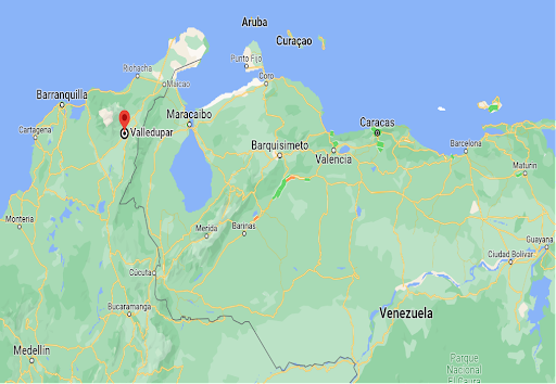
Geographically, Valledupar is bordered to the north by Riohacha and San Juan del Cesar of La Guajira department. To the south, it’s adjacent to El Paso and Los Robles La Paz in Cesar; to the east by Villanueva and Urumita of La Guajira; and to the west by Fundacion and Aracataca in Magdalena.
The municipality spans approximately 4,977.96 km². Of this, the Arhuacos Indian Reserve covers 72,660 km², the Kogui and Wiwa Indian Reserve occupies 399.52 km², and the Sierra Nevada de Santa Marta National Park stretches over 425.60 km².
Valledupar, positioned southeast of the Sierra Nevada de Santa Marta, is situated at an approximate latitude of 10.4631° N and a longitude of 73.2532° W. The city sits at an elevation of around 169 meters (554 feet) above sea level.
Home to a rich biodiversity, especially in the Sierra Nevada de Santa Marta and Serrania del Perijá mountains, the area is recognized as one of the global biodiversity hotspots. A recently identified bee species was found in the municipality’s rural parts and named Stelis vallenata, paying homage to the region’s Vallenato music.
The Turpial bird symbolizes the city. Parrots, which frequent the local fruit trees, are other prominent avian residents. During colonial times, the Spanish introduced various European animals and plants. Mango trees, brought by the Spaniards, are now a common sight, although the city’s emblematic trees are the Yellow Tabebuia, locally known as “Cañaguate” and Puy. These trees blanket the region in yellow blossoms during the dry spells.
Protection and management of the region’s natural resources fall under the Colombian Ministry of Environment, the local agency Corpocesar, and the Environmental Police of the Colombian National Police, supported by other non-profit entities.
The region’s climate is influenced by its altitude. Divided between mountainous terrains and plains, the area experiences two dry and two rainy seasons annually, with variations due to El Niño and La Niña events. Snow graces the mountain peaks during the rainy season. Occasional hailstorms and thunderstorms might strike the area, which also gets minor effects from the Caribbean hurricane season. While the rainy season sees flourishing greenery, the dry season turns the vegetation predominantly yellow, and water bodies recede. In 2013, based on IDEAM’s records, Valledupar was deemed the hottest location in Colombia on average.
Population
572,619(2023)
560,903(2022)
547,790(2021)
The population of Valledupar experienced a growth of 2.4% from 2021 to 2022, increasing from 547,790 to 560,903. Subsequently, from 2022 to 2023, the population saw a growth of 2.1%, reaching 572,619.
One photo representative of the city
The Plaza Alfonso López, formerly known as Plaza Mayor de Valledupar, stands as Valledupar’s central square. This plaza was originally inhabited by the indigenous Chimilas from the Eupari tribe before the mid-15th-century arrival of Spanish explorers. On January 6, 1550, Hernando de Santana, with the aid of notary Juan de Castellanos, established Valledupar at this very location. The earliest Spanish inhabitants chose to reside around this square. They employed colonial Spanish architecture to construct landmarks like the church of the Immaculate Conception, a convent, and surrounding mansions. Additionally, the Nuestra Señora del Rosario church and its accompanying monastery were built a short distance away.
Serving as the city’s communal hub, the square hosted military parades and became the nexus for political, cultural, and commercial gatherings. Notably, during Valledupar’s Holy Week, it became a focal point for the revered Ecce Homo celebration.
The plaza played a pivotal role during Valledupar’s 18th-century independence movement, acting as a gathering spot for those seeking to free the region from Spanish rule. María Concepción Loperena, a notable figure living near the square, was among these revolutionaries.
In 1936, Eloy Quintero Baute, a political leader and farmer, introduced mango trees to the plaza, reminiscent of those on his ‘Bélgica’ farm, with the maintenance entrusted to Emelina Quintero Araújo and Abigail Escalona Martínez.
Significant transformations to the square occurred in the mid-20th century. Under Mayor Jorge Dangond Daza, the area saw its first paved streets, and a sizable cement platform was introduced as a venue for political rallies and musical events, predominantly showcasing vallenato performances.
Liberal party leaders later renamed the Plaza Mayor of Valledupar in honor of ex-president Alfonso López Pumarejo, a decision influenced by his mother’s Valledupar origins.
1968 marked the square’s hosting of the inaugural Vallenata Legend Festival. By 1986, amidst much debate, a modern stage named Francisco ‘El Hombre’ was established to accommodate the increasingly popular vallenato music festivals. Consequently, Carrera 5, situated between 15th and 16th streets, was integrated into the plaza.
2007 saw an unsuccessful bid by architect Gonzalo Orozco Daza to dismantle the ‘Francisco El hombre’ stage, claiming it encroached upon public space. Despite objections, this proposal was eventually abandoned. In 2010, Mayor Luis Fabián Fernández’s efforts to revamp the plaza met resistance and were turned down. Although the main events of the Vallenato Festival moved to the Parque de la Leyenda Vallenata in 2004 due to space constraints, the plaza’s Francisco El Hombre stage still hosts several festival competitions.


Etymology
The “Valledupar” combines two elements: the Spanish term “Valle”, signifying “Valley”, and “Upar”, the name of a prominent indigenous Cacique (tribal chief) from the region. Together, “Valledupar” suggests “Valley of Upar” or “Upar’s Valley”. The designation is a tribute to Cacique Upar, a legendary indigenous leader renowned for his staunch resistance against Spanish invaders. This intertwining of indigenous history and natural geography underscores the rich heritage of the area, giving insight into its origins and the significance of local indigenous cultures in shaping its identity.
What the city is known or famous for
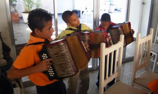
Valledupar stands out primarily for being recognized as the cradle of vallenato music, which holds a cherished spot in Colombia’s cultural heart. This distinctive music genre, emblematic of Colombia, is a harmonious blend of accordion, caja (a compact drum), and guacharaca (a ridged wooden percussion tool). With roots tracing back to European, African, and Indigenous traditions, vallenato epitomizes the country’s diverse cultural heritage. Notably, the guacharaca instrument, inspired by the bird it’s named after, has Indigenous origins and was traditionally used in hunting and romantic serenades.